Official-source prevention update · Published September 1, 2026
Southeast Fire Centre campfires allowed again Sept. 1 — but larger open fires remain banned
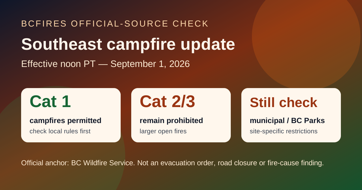
BC Wildfire Service says Category 1 campfires are permitted again throughout the Southeast Fire Centre effective 12:00 noon Pacific Time on Tuesday, September 1, 2026. The same bulletin says larger Category 2 and Category 3 open fires remain prohibited, along with several listed activities and pieces of equipment.
If life or property is at immediate risk, call 911. To report a wildfire, call 1-800-663-5555 or *5555 on a cellphone.
This is a prevention/restriction source-card. It is not an evacuation order, evacuation alert, road closure, detour, safe-return clearance, fire-boundary update or wildfire-cause finding.
What changed Sept. 1
- BCWS says Category 1 campfires are permitted again throughout the Southeast Fire Centre at noon PT Sept. 1.
- The bulletin names the Rocky Mountain Natural Resource District and the Selkirk Natural Resource District in the Southeast Fire Centre area.
- BCWS says recent precipitation, improved overnight recoveries and forecast conditions reduced the need for the campfire prohibition.
- A Category 1 campfire is still limited by the Wildfire Regulation definition: no larger than 0.5 metres high by 0.5 metres wide and used for recreational or First Nation ceremonial purposes.
What still needs a live check before anyone lights anything
- Category 2 and Category 3 open fires remain prohibited in the Southeast Fire Centre as of Sept. 1.
- BCWS says air curtain burners, carbonizers, fireworks, binary exploding targets, burn barrels or burn cages of any size or description, and controlled air incinerators remain restricted in the bulletin.
- The Southeast Fire Centre restrictions page also lists sky lanterns, certain wood-fired devices and recreational ORV operation on Crown land among additional restrictions.
- Municipal, regional district, improvement district, First Nation, BC Parks and site-specific rules may be stricter than the BCWS fire-centre bulletin. Check those live sources first.
Where the order applies
BCWS says the continuing Southeast Fire Centre restrictions apply outside municipal boundaries, to specified Crown/public land categories inside municipal boundaries, and to all lands in the Villages of Slocan and Silverton. Local governments can still impose different or stricter restrictions inside their own boundaries.
Why this matters
This is good news for campers and rural residents in the Southeast, but it is not an all-clear for larger burns. The practical rule is simple: small campfire does not mean burn pile, fireworks, burn barrel or backroad activity is automatically allowed.
Official-source road and emergency context captured with this update
BCFires also captured EmergencyInfoBC and DriveBC/Open511 as context. Those feeds still need to be opened live before travel, return-home decisions or sharing screenshots as current instructions.
| Severity | Road | Updated | DriveBC/Open511 context |
|---|---|---|---|
| MAJOR | Other Roads | 2026-08-28T16:15:03-07:00 | Pavilion-Clinton Rd, in both directions. There is a wildfire between Pear Lake Road and Mowhich Road. Road closed. Road closed to all traffic except emergency vehicles. Next update time Tue Sep 1 at 12:00 PM PDT. Last updated Fri Aug 28 at 4:15 PM PDT. (DBC-93772) Open Open511 event |
| MAJOR | Big Bar Reaction Ferry | 2026-08-31T07:25:38-07:00 | Big Bar Reaction Ferry. There is a wildfire at Big Bar Reaction Ferry (Big Bar Reaction Ferry). Ferry route closed. Next update time Wed Sep 2 at 10:00 AM PDT. Last updated Mon Aug 31 at 7:25 AM PDT. (DBC-93766) Open Open511 event |
| MAJOR | Other Roads | 2026-08-31T12:11:48-07:00 | Silver Skagit Rd, in both directions. There is a wildfire between Silver Skagit Rd 6km mark and USA/Canada Border. Road closed. Closure point is approximately 6km south of Flood Hope Rd due to Provincial Parks closure caused by Hozomeen Mountain Wildfire. Silver Lake remains open. Ross Lake Campground and Skagit Valley Park closed. Next update time Fri Sep 4 at 12:00 PM PDT. Last updated Mon Aug 31 at 12:11 PM PDT. (… Open Open511 event |
| MAJOR | Highway 1 | 2026-08-31T12:35:24-07:00 | Highway 1 (TransCanada Highway), in both directions. There is a wildfire between Anderson River Mainline and Thomas Rd for 2.5 km (20 to 23 km north of Yale). Road open to traffic. Single lane alternating traffic. Watch for traffic control. Through a 2km section extending 1km south of Alexandra Tunnel to 1km north of Alexandra Tunnel. Obey signage and expect delays of up to 30 min. Next update time Tue Sep 1 at 11:00… Open Open511 event |
| MAJOR | Highway 97 | 2026-08-31T12:47:42-07:00 | Wildfire from Highway 97, In Spallumcheen and At Highway 97 and Old Kamloops Road to At Salmon River Road. Road open. Watch for traffic control. Last update: August 31st, 2026 at 12:47pm PDT. Next update: September 4th, 2026 at 12:00pm PDT. No stopping between Head of the Lake Rd and Grandview Flats Rd. Open Open511 event |
| MAJOR | Westside Rd | 2026-08-31T12:48:00-07:00 | Westside Rd, in both directions. There is a wildfire between Komasket Rd and Simla Rd for 8.1 km (48 to 56 km east of West Kelowna). Westside Rd is open. No stopping between Irish Creek Rd and Komasket Rd. Use caution. Avoid non-essential travel. Local traffic only. Next update time Fri Sep 4 at 12:00 PM PDT. Last updated Mon Aug 31 at 12:48 PM PDT. (DBC-93854) Open Open511 event |
| MAJOR | Other Roads | 2026-08-31T13:55:04-07:00 | Meadow Lake Rd, in both directions. There is a wildfire between Dog Creek Rd and Gang Ranch Rd. Road closed. Road closed to all traffic except emergency vehicles. Next update time Fri Sep 4 at 12:00 PM PDT. Last updated Mon Aug 31 at 1:55 PM PDT. (DBC-93781) Open Open511 event |
| MAJOR | Other Roads | 2026-08-31T13:55:23-07:00 | Big Bar Rd, in both directions. There is a wildfire between Little Big Bar Lake Rd and The Big Bar Ferry. Road closed. Road closed to all traffic except emergency vehicles. Next update time Fri Sep 4 at 12:00 PM PDT. Last updated Mon Aug 31 at 1:55 PM PDT. (DBC-93680) Open Open511 event |
EmergencyInfoBC action pages sampled
- Evacuation Alert issued for some areas in Electoral Area B — modified 2026-08-28T13:18:56. Open EmergencyInfoBC page
- Regional District of Bulkley-Nechako evacuation information — modified 2026-08-28T17:53:02. Open EmergencyInfoBC page
- Evacuation Alert issued for parts of Clinton — modified 2026-08-25T13:13:19. Open EmergencyInfoBC page
- Evacuation Alert RESCINDED for Oceanview & Kelvin Grove roads — modified 2026-08-24T12:02:12. Open EmergencyInfoBC page
- Cayoose Creek Indian Band evacuation information — modified 2026-08-15T11:38:07. Open EmergencyInfoBC page
- Cook’s Ferry Indian Band evacuation information — modified 2026-08-27T14:34:16. Open EmergencyInfoBC page
- Lower Similkameen Indian Band evacuation information — modified 2026-08-17T17:13:54. Open EmergencyInfoBC page
- City of Revelstoke evacuation information — modified 2026-08-31T18:37:31. Open EmergencyInfoBC page
Source package
BCFires saved the source trail under research/southeast-fire-centre-campfire-prohibition-rescinded-september-1-2026-2026-09-01/source-note.md, including the BCWS bulletin capture, Southeast Fire Centre restrictions page, open-burning definitions, EmergencyInfoBC/DriveBC context captures and a claim table.